

Texas Trip: Big Bend National Park Texas Trip: Big Bend National Park,September 16-20, 2019
- Erin

- Sep 20, 2019
- 15 min read
Written by Roger.
Texas Trip: Big Bend National Park
Texas Trip: Big Bend National Park,
September 16-20, 2019
From Fort Davis, we drove south back through the town of Alpine and then out in the Chihuahuan Dessert to the little town of Terlingua aka Study Butte....pronounced "Stooood-ee Beaut" by all 110 residents. I prefer calling "Stud-ee Butts", which conjures an interesting activity. The two-hour drive was mostly devoid of traffic.
📷
Big Bend National Park
We met our guide, Erin, at the rest area across from the only gas station in town. She and her twin sister run a guide service down her through the winter and they move back to the Smokies in the Spring where they do white water rafting all summer. Her Tennessee accent and the enthusiasm she has for her profession soon became obvious.
We immediately left for the Big Bend National Par Western Entrance, only a few miles further South. I sat in the front passenger seat of her van to better hear her descriptions of the flora, fauna, geology and history of the park...all of which I have forgotten but are easily found on Google or Erin & Erica's book if they ever write one.
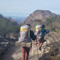
Generally, I have to let the photos tell the story of Big Bend N. P. because the words are hard to find. It is an 800,000 acres give or take a few. Fortunately, they don'y have much grass to mow or trees to prune. Erin pointed out that a mesa is a flat-topped piles of rocks that is wider than it is tall, a butte is the same thing but it is taller than it is wide, a plateau to a big mesa and a long, straight, hard 12 foot wide surface is a road. The big jagged rocks of all shapes and sizes a mountains . Finally the brown water flowing through the rocks is the Rio Grande River with Mexico on the other side. It doesn't take long to sense the immensity of the park and its hot, parched, isolated feel.
Boquillas Canyon Hike
We drove an hour into the par to the Mexican Border and took a lovely one or so mile walk up Boquillas Canyon for our first glimpse of the muddy brown Rio Grande as it winds its way along sandy shorelines then into the canyon with its vertical rock walls. The Rio Grande is certainly not the size of the Mississippi but it can be when it rains. Today it was shallow and not fast moving but then there are days when it can't even be crossed by boat. The river is lined with cottonwoods, river reeds and all forms of cacti. It was about this point that we realized it was just hot, it was really, really hot. I've never bought into this thing about "but it's dry here" to compensate for the torrid temperature. Hot is hot wherever you are. Humidity is just another weather phenomenon like rain. Erin admonished us to consume water constantly but not sure if that included margaritas and beer.
📷
Boquillas, Mexico Tour
We too a row boat ride across the Rio Grande into Mexico after passing though Passport Control on the USA side of the river. This pleasant, one-man operation nicely pointed out that we should check our passports and make sure they are current if we should want to return to see our grandchildren grow up.
Boquillas is a small community of about 110 on the Mexican shore of the Rio Grande (Rio Bravo to the Mexicans) opposite the Big Bend N. P. It was a victim of the 9/11 Attack when the border was closed. Before that, the town's population easily crossed into the U. S. to work, get gasoline, propane groceries and visit relatives in the U. S.. After that fateful day, free transit ceased and the community became totally isolated from both the U.S. and its own native communities. I believe that Erin told us that they have to go over a hundred miles to get anything including gas...but it taes gas to get there. They now exist on Big Bend Par tourists who can pass through the checkpoint and take a row bow ferry across to the southern shore. The "ferry" costs $5.00 round trip. Wading is an option but not recommended due to the swift current even though the river is only hip-deep at best. Once on the Mexican shore, a tourist has four options to get to the actual town of Boquillas: walk; take a truck; take a horse or take a burro. A burro also costs $.00 round trip. Since we were here for some walking, we took that option although we probably should have at least walked a burro to help the struggling economy.
We were offered a guide for the one mile walk up to town but passed on that as well. However, a friend of Erin's named Felix accompanied from the "ferry" to the village and back. Felix road a horse. As we climbed a slight hill along the dusty road into the village, we were "accosted" by a cute three year old boy selling embroidered bracelets for $3.00 each. Having kids do the selling is a great marketing gimmick...who can turn down those cute little faces. Megan wanted to get him down to a buck but I insisted we buy at list price...which we found out was highly variable depending on the junior merchant.
Boquillas is a Mexican village right out of a Hollywood set. There are certain key elements that make it authentic: dusty streets; adobe buildings; roaming dogs; open-air restaurants; a Catholic church; a school; pick-up trucks; donkeys; lots of children and more bars than San Quentin. Felix was keen on taking us to his house where we dutifully bought some trinkets from his wife including more bracelets at 5 bucks a pop...but then we were in the classier part of town.
Felix too us down to the river to see the hot springs pool which can be plugged up with sandbags and used as an outdoor bathtub. This was pretty cool. I want one on Lake Wylie but first I need to find the hot spring on our lot. From his casa, Felix guided us to his sister's restaurant, a nice outdoor cafe on the main (only) drag where I consumed a Mexican beer and two Margaritas to stay hydrated. I had three Tacos Cabrito (goat) that was worth the walk and $5.00 "ferry" ride and more. Megan and Erin each had Cheese Quesadillas, which reported were also great.
Saying adios to Boquillas, we waled back to the Rio Grande but first stopped for a brief dip in one of the hot-springs pools. Since the ambient temperature was about 200 degrees, the hot springs were actually refreshing. From there, we crossed the Rubicon back to the U.S. and had to go through the typical post-9/11 immigration rigmarole. First, our officer who gave us the advise before we crossed into Mexico gave my pack a thorough inspection to see if I was carrying more than $2,000 of trinkets...the entire monthly GDP of Boquillas. Only one of the two kiosks for Passport Control was operational, we had to wait awhile before our turns came to place our GOES card in the machine, have our photos taken and then be interviewed by an officer who, for all I know, was in India. The guy said "Hello, Roger. Are you travelling alone. I said I was with my wife, Megan, and that was all he needed. Megan must have had some pull. Erin was not so lucky. They thought she was her twin sister, Erica. Erica, however, must have had the same pull as Megan so they let her back in.📷
📷
📷anta Elena Canyon Canoe Trip
📷I got up early to see the sunrise fom our little veranda. Actually I was awake at 6 am and said "what the heck. Let's see if the sun comes up down here." Sure enough, it came up and kept going up until noon just like at home.
After breakfast, we met the "other" twin, Elena, and three other guests for our canoe trip into the Santa Elena Canyon, the most visited attraction in the park. The other guests were all "foreigners" that I assume were here legally. Dan and Mary were a couple from Ontario that are pursuing their goal of visiting all of our national parks and Emma was a Yorkshire gal visiting Texan friends on an extended holiday in the Americas.
During our hour-plus van ride into the park, Erica gave us a running history starting with the base geologic plates converging millions of years ago up through last week. I must admit that when it comes to geology, my earwax builds to a point that I start musing about dinosaur guts all over the ground and giant rattlesnakes flying though the air. I'm pretty much the same when it comes to flora and fauna, not because I am not interested but because I know I'll will forget it by nightfall. I prefer to just be overwhelmed by the sensory experience of this vast, fascinating landscape. When she got to the history of the cowboys and Indians and the cavalry and settlers on our return trip, my ears unclogged and my attention span lasted longer than my normal milliseconds. I won't go into the detail here because I'd have to make it up anyway. Bottom line, the Indians are gone, the Texans are here Mexicans can no longer walk across the river to buy groceries and gas. Progress???
The only strenuous part of the day was getting the canoes down to the canyon and into the water. Hiawatha, I mean Erica, gave us all a primer on the do's and don't of paddling a canoe in the right direction, how to don a life jacket while trying to stay afloat in 18 inch deep water and what to do in the unlikely event that we have lo land on water. Once in the water, it soon became apparent that here instruction were well-received and properly executed by all. No one fell overboard and bruised their knees, nobody had the canoe sink and everyone returned safely to repeat the experience of hauling the canoes back to the van.
Now, let me cover the trip into the canyon, a absolutely breathtaking experience. The walls of the canyon are over a thousand vertical feet. We only paddled about 2.5 miles upriver but the vistas around each bend grew more and more spectacular. The natural breeze and the shade created by the deep gorge, made for a very nice outing compared to the high temperature out on the dessert floor. We came to just the right place at the right time.
The water level, by my judgement averaged no more than 12-18 inches. I never encountered anywhere deeper than maybe 2.5 feet. The current was mild so paddling upstream was easy and drifting downstream was relaxing. We stopped and had lunch under an overhang out of the sun. Megan and I had bought sandwiches that morning at La Posada's where we had had breakfast. Terrific meatloaf sandwich for me and a chicken salad for Megan. I also happened across some cans of Modelo by accident while at the market the night before.
After lunch three of us took a dip in the Rio Grand. I laid down in the deepest part I could find and my bellybutton did't get wet. However, looking at the water stains four feet up the wall, I can appreciate that you would not want to be here during a flash flood. Overall, if you ever happen to find yourself driving though Terlingua on the way to El Paso and only have time for one stop in Big Bend N.P., make sure it is to Santa Elena Canyon and absolutely take a canoe or kayak up into the canyon!📷
Terligua Ghost Town
Terlingua Ghost Town is about five miles west of the "hustle-bustle" of downtown Terlingua/Study Butte. The Ghost Town was once the home of the Chisos Mining Company, a cinnabar mining operation that dried up when the mercury that they smelted was no longer needed for bomb detonators. All that was left was cemetery and some old adobe buildings. Today, the Ghost Town is a vibrant community of the most eclectic housing that varies from dilapidated trailers and motor homes, to eccentric homes complete with pirate ships and some strange yard art. Anchoring this unique community, which I think is home to original Chili Cook-off, is the Starlight Theater, the Terlingua Trading Company and our favorite breakfast spot, La Posada Magrano (or something to that effect).
We took a walk through the graveyard, which is a lot like a permanent Day of The Dead shrine. All of the graves are unique, some are decorated and more than a few a recent, not just old miner graves. The Trading Store and the porch and parking lot is the center of the gossip mill of Ghost Town. All you need is la beard, a long-neck Lone Star beer, jeans and a tie-dye t-shirt to fit in. Ghost Town is also the home of the Terlingua Pride Parade. We fit right in from the "git-go". Zoning ordinances are not high on the Ghost Town Planning Commissions list of priorities. The whole place could be a scene from WaterWorld. In fact, Kevin Costner may be appearing at the Starlight Theater next year.
Indian Head Trail
After breakfast at La Posada Milagro, We met up with our Step-In Guide for a day on 4-wheel drive touring and hiking. We had already met Flora and Fauna, our guides for the Boquillas Tour (Erin) and the Santa Elena Canyon Canoe Trip (Fauna) and today we got to meet the third member of the triumvirate that makes up Big Bend Boating & Hiking Company. Flora and Fauna had given us a hint that Jimmy, Fauna's husband, was a character and a true Redneck...in the best sense of the expression. Jimmy was everything they said and more. Whereas Flora and Faun a now every detail of the park and its history, Jimmy brings it to life through his stories of life in the dessert. The three of them need to have their own TV show where two Pioneer Women meet the Survivor in the desert.
Jimmy first took us to what he called his "hidden gem", Arrowhead Trail is a few miles down a dirt road behind the gas station. Jimmy, aka Pathfinder, directed me to the trail head where we loaded up on water and headed into the desert for a mile and half or so.
As we walked, Jimmy gave us a survival lesson on plants we could eat, use for needle and thread, and other tips I've already forgotten since I have no intent to go far enough into any desert to get lost any time soon. We heard a lot of tales about Pathfinder's fondness for rattlesnakes. He never saw one he didn't want to see dead. I must say that if I happen to wander off in one of North Carolina's deserts, I'll know not to pet a rattlesnake or juggle a cactus.
I loved the way Pathfinder explained things with a little anecdote from his experiences with his recently departed Dad and his grandfather. I wish I had recorded some of these stories. Here's my favorite: On the anniversary of his father's passing this December, Jimmy will be hosting a family reunion at which time he will shoot two shotgun shells loaded with some of his Dad's ashes into the desert as his Dad requested. It was obvious the loss of his Dad is still causing raw emotions but to Dad's credit, he's going out with a bang. I'll probably remember and repeat this story more often than I will about seeing the interesting cacti along the trail.📷
Grapevine Hills Trail & Balanced Rock
After Indian head Trail, we drove 45 minutes or so into the park to the Grapevine Hills Trail and up to Balanced Rock. This was a great walk in much greener, boulder-strewn area. Pathfinder passed along some helpful hiking tips to avoid getting lost such as stay on the marked trail and not climb over barriers. He pointed out some interesting types of poop as we moved along and gently began climbing up to Balanced Rock.
Pathfinder spotted an audad (pronounced aw-dad)) on the mountain top about fifteen miles above us. It was pretty impressive when view through his binoculars. Soon, a second goat came along and they moved with far more agility than me across the ridge before disappearing...or taking a poop.
Megan made it about halfway up the slope and was happy to just just look at the photos I was going to take. The last bit of the trail...calling it a trail is a stretch...was steep and the footing was difficult. The rewarding view was worth the effort although my heel problem came into play as we climbed back down.
The audad made another appearances on the way down and I was able to get a decent photo with my Google phone.
Pathfinder shared some stories with us about his days as an EMT and some of his projects. My favorite was one about their Redneck Hot Tub, which consists of a circular cattle feeder tub, a wooden power line spool and an aluminum box with a wood-burning stove inside. It's filled with roof run-off water. This could have patent possibilities.
After the hike, we drove to the Visors Center at Panther Junction where we ate our sandwiches from La Posada that we picked up at breakfast. After that, Megan and I watched a short movie on the park before we headed back to Terlingua. Pathfinder shared some EMT stories with us on the way
back and how much he enjoys helicopter rides. Then there was the story of the time he too his ids to the drive-in theater and took the left his window behind with the speaker attached. And the time he three a rattlesnake from a bucket on his sleeping cousin. I could go on but I want Pathfinder to have some material to share on the TV reality show the three of them should produce.
Thursday the 19th was our first day in the park without a guide. Now I was stuck making up names for the various cacti, birds, plants, grasshoppers, streams and mountains....and I got to tell my stories to a captive audience. Pathfinder had left us with some recommendations based on his assessment of our limitations and lack of any sense of direction...or sense for that matter.
We loaded up the Wrangler with water and two energy bars in case we got lost for more than an hour in the desert. After breakfast at the best and only gas station in Terlingua, we headed off into the park on today's adventure.
The Chisos Basin is a totally different microclimate than the desert floor we had be covering the last few days. At the higher elevation, you can actually see trees starting to appear as you climb up the mountain. The temperature must be a least 10-15 degrees cooler with a nice breeze funneling through the passes. We stopped at the Visitor Center and the Ranger told Megan and everyone else that came in that we should be off the trail by noon and carry extra water due to expected high temps today. This seemed a bit extreme but we were not planning any long hikes anyway.
We started off immediately on the wrong trail. Pathfinder told us to stick to the paved trail to get the best view of The Window and avoid the issues Megan has with switchbacks and heights. We saw a sign directing us to The Window Trail and followed the rocky path for about a mile or so downhill and around some switchbacks before we questioned why it wasn't paved. We decided we'd hike back up and try another trail since the actual Window was still of in the distance and from our current vantage point, there was much of a view. The hike back up was hot and tiring.
We found the paved trail at the top pointing to a lookout point. This "hike" was about a quarter mile round trip but worth every step. The view down to the desert floor though the "window" created by the mountains was beautiful. So ended our first solo venture into the back country of Big Bend...of course we were there with about another hundred hikers, some older and some younger than us plus there was a general store, flush toilets, a hotel and a restaurants with a hundred feet so we wouldn't have even needed our energy bars if we got lost. All we had to do was walk over to the Visitor Center and ask directions.
The nearby Lost Mine Trail was another recommendation of Pathfinders but with this admonition: "Walk up the trail a mile or so until you reach a place with two benches. Megan should wait there and Roger should go on another fifty yards to a lookout point to take a photo. Don't go on to the top because of the height and drop-offs that Megan would not appreciate."
The trail was reasonably well groomed with a gentle slope rising up the mountain, We had taken the last slot in the parking lot so we expected the trail would be busy with hikers that had not received Pathfinders instructions. After seeding the warnings to report any bears, mountain lions of mutilated hikers on or near the trail to the nearest Ranger Station, Megan decided she was not going to stop at the benches and be bait for some wild animal. She braved the fifty additional yards and we walked back down. Got some nice photos along the way.
By now it was getting warm and we decided to break for lunch at the Chisos Basin restaurant. The View of The Window from the restaurant window was better than the food but the food was a lot better than the energy bars we toted along.
Old Maverick Road
After lunch, Megan too the wheel and drove us down to Santa Helena Canyon where we canoed a few days ago. I wanted to see how high the water had risen after the rains the night before. Terlingua Creek wasn't exacting raging but it was flowing enough that hikers could not easing cross it to get into the canyon. Our real purpose for driving to the canyon was to take the Wrangler on the 12 mile Old Maverick Road, a gravel road darn near poker-straight that purportedly saves 45 minutes getting back to town. The signs advise that you need a 4-wheel drive vehicle for this route, which is highly advisable not because of traction but clearance over come of the bumps and rocks along the way. We never put the Wrangler in 4-wheel mode...primarily because we could figure out how to. Our Navigator only requires pushing a button. The Wrangler requires reading the manual, a task we decided to ignore and take our chances.
We stopped a few times for photos and to replace the filling in our teeth but were proud that we didn't get lost and drive on out endlessly into the desert, but we still had our energy bars just in case. Pathfinders advice to stay on the trail was permanently etched in our brains.

Comments